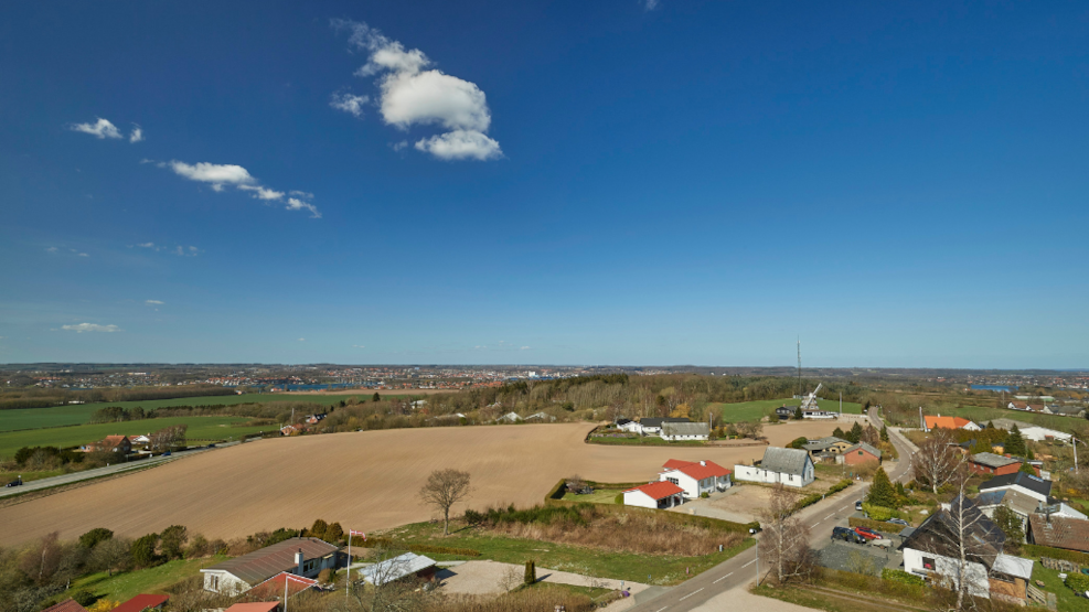
Bregninge Kirkebakke - church hill
From Bregninge Church Tower, you have the highest point of Tåsinge and a fantastic view of the South Funen Archipelago and Svendborg.
Visit Bregninge Church Hill
The Church Hill on which Bregninge Church is located is in the northern part of Tåsinge, and you can easily reach it by following route 9 from Svendborg. It is possible to park at the church's parking lot.
What to experience at Bregninge Church Hill
Bregninge Church Hill (74 m) is a prominent dome-shaped hill formation, whose surface is composed of four to seven parallel ridges with a slightly arched course. This means that the top of the hill is the highest point of Tåsinge, and if you choose to climb the church tower, you have a unique view over Tåsinge and the archipelago. It is said that from the tower, you can see 28 islands, 65 churches, and 20 castles. The tower is open every day from 8:00 a.m. to 10:00 p.m.
Right across from the church is the Tåsinge Museum, a small museum telling the history of the region. Here, you can, among other things, learn about Elvira Madigan and Sixten Sparre.
Geological perspectives at Bregninge Church Hill
Bregninge Church Hill's oval shape (5.5 x 2.5 km), its imposing size, and unique location have contributed to the debate about its formation history. It is likely an ice marginal hill, where several glacial advances may have contributed to its formation. However, the hill does not seem to represent a genuine ice marginal line, as no continuation of such a line has been found in the adjacent landscape.
The interior of the hill consists mostly of frequently alternating layers of meltwater deposits and moraine clays. But here, layers of the over 53,000-year-old water and wind-deposited 'Hvide Sand' (White Sand), layered meltwater clay deposited in ice-enclosed lakes, and intrusions of more than 42 million-year-old 'plastic clay' between layers of ice age deposits can also be found. This suggests that the core of the hill is composed of layers that have been pushed up, folded, and thrust over each other by one or more glacial advances.
From the summit by the church, the undulating landscape slopes down towards the coasts. At levels around 40-50 m above sea level, several small and short valleys eroded into the slopes can be seen. Allegedly, they are due to water erosion from springs bubbling up from the ground in connection with water-bearing clay layers inside the hill. Today, most of the valleys are dry.
A good place to experience the landscape is Løkkekærs Banke ('Casanova Hills'), 200 m northwest of Bregninge Church. The name comes from the former dance establishment 'Casanova' in Gerritsgade in Svendborg, whose charismatic owner, Niels Christoffer Sørensen, once owned Løkkekærs Banke.
On the north side of Bregninge Church Hill lies Ingers Høj, a burial mound from the early Bronze Age. It measures 41 m in diameter and 7 m in height and is one of the largest of its kind in Denmark. The mound is also a good vantage point.
Bregninge Church Hill is part of the South Funen Archipelago Geopark
In 2018, Svendborg, Faaborg-Midtfyn, Langeland, and Ærø decided to establish the South Funen Archipelago Geopark with the aim of being designated as a UNESCO Global Geopark. The purpose of the geopark is to create and preserve an area for both people and nature.
A UNESCO Global Geopark should highlight the geology, nature, and cultural history of an area and convey a message that humans are part of life on Earth. That we are all dependent on the Earth's resources, affected by climate change, and responsible for sustainable development.
The South Funen Archipelago Geopark tells the story of a dramatic rise in sea levels in South Funen and the islands. A rise in sea levels that shaped a very special nature that has formed the basis for the area's existence and cultural identity over the past nearly 10,000 years. It is the story of how the landscape and archipelago continue to change and define how we as humans live today. And the South Funen Archipelago Geopark is primarily about understanding how, through sustainable development, we can continue to preserve our special geological, biological, and cultural heritage.